Visiting Pictured Rocks National Lakeshore


Pictured Rocks National Lakeshore, managed by the National Parks Service, was the first of the US National Lakeshores.  This Pictured Rocks trip planner will provide all the details you need.  We’ll talk about hiking at Pictured Rocks, boating, and kayaking, among several other things.  You’ll be able to plan an exciting trip to Northern Michigan, and visiting Pictured Rocks National Lakeshore.

Located along the south shore of Lake Superior in Michigan’s upper peninsula, it is a gem in the Midwest, perhaps the most beautiful shore in the United States.  There are numerous Pictured Rocks attractions, including colorful limestone cliffs, several waterfalls, dunes, beaches, lighthouses, shipwrecks, and old growth forest.  This results in a plethora of things to do at Pictured Rocks. 

I am Amy Piper, world traveler, and founder of Follow the Piper. I was born and raised in Michigan and have always had a home here. Exploring the Great Lakes is one of my favorite things to do, and I am excited to share the adventurous things to do in Pictured Rocks National Lakeshore with you.

This Pictured Rocks Trip Planner Includes:
    • What Causes the Colors in Pictured Rocks?
    • Pictured Rocks Logistics
    • Things to Do in Pictured Rocks National Lakeshore
    • Pictured Rocks Attractions
    • If You Visit Pictured Rocks
    • Eating in and Near Pictured Rocks
    • Where to Stay Near Pictured Rocks
    • What to Pack for Visiting Pictured Rocks


So if you are ready to see some of the beautiful scenery, and find out what an exciting adventure you can have, let’s get on with it.

What causes the colors in Pictured Rocks?

Colored striations on rocks at Pictured Rocks National Lakeshore.

The myriad of colored cliffs are among the top Pictured Rocks attractions.  Minerals produce the various colors in the Pictured Rocks. The blue and green colors come from copper, the red and orange from iron, manganese produces brown and black colors, while the white comes from limonite. The beautiful colors come from the groundwater carrying these minerals, coming through cracks in the rocks and trickling down the rocks.

The Logistics of Visiting Pictured Rocks National Lakeshore

Essential Pictured Rocks trip planner information.  

Getting to Pictured Rocks

Entrance sign for Pictured Rocks National Lakeshore, which you will see when visiting Pictured Rocks.

Pictured Rocks National Lakeshore is located on the south shore of Lake Superior in Michigan’s Upper Peninsula, between Munising and Grand Marais.

If you are arriving by air, fly into Marquette (MQT), Escanaba (ESC), or Sault Ste. Marie (CIU), Michigan, the closest being Marquette. Keep in mind there is also a Sault Ste. Marie, Ontario, Canada, so don’t confuse the two when making your flight reservations. Once you have reached Michigan’s Upper Peninsula, you will need a car.

If you are driving, bear in mind that there is only one bridge passing from the lower peninsula to the upper, on Interstate 75.  Traffic can be quite heavy during the mid-summer months, so plan your travel time accordingly.

If you are visiting Pictured Rocks from the Chicago area, you may want to consider an overnight pit stop in Grand Rapids, before continuing upstate.  If you are coming from western states, it may be easier to come through Wisconsin, using US Route 41 out of Green Bay.  If you are coming from the eastern states, consider stopping for a couple days in Frankenmuth for something fun and different!

Entrance Fees to Pictured Rocks National Lakeshore

Effective March 1, 2022, there is an entrance fee for Pictured Rocks National Lakeshore payable at a Visitors Center.  The charge is $10.00 per car or motorcycle, and in the case of cars, the pass should be displayed inside the front window when parked.  For those arriving without a highway vehicle,  such as hikers, bikers, snowmobilers and boaters, the charge is $5.00 per person.

Some of the things to do at Pictured Rocks will involve an additional fee.  As expected, the various boat tours available involve purchasing tickets.  Kayaking at Pictured Rocks may require equipment rental, unless you bring your own.  Long distance hiking at Pictured Rocks may involve the use of the Altran shuttle service, which requires an advance reservation and a small charge.

The Best Time for Visiting Pictured Rocks

Memorial Day through Labor Day is the best time to visit, but of course, it is the busiest. September and early October are an excellent time to view the brilliant fall foliage. 

Keep in mind that Lake Superior is the largest fresh water lake in the world, containing enough water to cover the lower 48 states to a depth of 5 feet.  Midwesterners are aware, but those from further away may not realize that the Great Lakes, and in particular Lake Superior, create their own weather patterns.  Temperatures along the lake drop faster than many other areas of the United States, so plan your dress and supplies accordingly.

Those that are accustomed to the winter weather will find a plethora of winter things to do at Pictured Rocks.  We won’t go into a lot of detail in this Pictured Rocks trip planner, but winter activities include skiing, snowshoeing, snowmobiling, ice climbing, and viewing ice formations.  Plus, the Pictured Rocks attractions all take on a magical wonderland appearance.

Things to do in Pictured Rocks National Lakeshore


Start at the Visitors Center

There are two visitor’s centers in Pictured Rocks.  The Munising Falls Visitors Center is open daily from 9:00 to 4:30 during the summer months, and on Wednesdays to Sundays the rest of the year.  The Grand Sable Visitors Center is open from 10:00 to 4:00 from June to September.  They are a perfect start to your visit to the park, as you can pick up maps for hiking in Pictured Rocks, get your National Park Passport stamped, and get any other information you may need.  It is very important to find out about any weather warnings that may be in effect.  There are also exhibits that explain the geology and history of the area.

If you are traveling with children, be sure to get a Junior Ranger guide book, so the entire family can embark upon the learning adventures that are part of earning the Junior Ranger badge. The Gypsy With a Day Job owners are big advocates of the Junior Ranger program.  

During the summer months, you will also find a schedule of ranger-led tours and discussions.  Pictured Rocks has ranger talks that include serenity beach walks on Wednesdays, lighthouse tour and lantern walk on Fridays and a wilderness canoe adventure on Saturdays.  These activities are educational and entertaining, and depending on your itinerary, you may wish to add some of them to your things to do at Pictured Rocks.

Take a Boat Tour

The stone arch covered with trees, at Little Portal Point, Pictured Rocks National Lakeshore.

I found the boat tour the best way to see the entire Pictured Rocks National Lakeshore. It’s suitable for all ages and activity levels.  It is the perfect way to have the best view of the shoreline.   Cruises run from mid-May to mid-October.  There are 4 cruise choices, which are best reserved ahead.

Cruises leave from the Munising, Michigan City dock, and all last from 2 to 2.5 hours.  I took the Spray Falls Tour, which lasts two hours and 15 minutes. Travel 32 miles round trip and see the brilliantly colored cliffs and sea caves. Some of the Pictured Rocks attractions along the shoreline include Lovers Leap, Indian Head, Miners Castle, and Chapel Rock, but I will give a longer list of them later.


Hike the Pictured Rocks National Lakeshore

There are 100 miles of trails going through the park, and offer a breadth of diversity, even for the National Park Service.  Day hikes range from a short 200 foot trail, to a 10 mile loop, and the back-country trail is 42 miles long.  Trails pass through wetlands, old growth white pine forest, upland maple forest, mature hardwood forest, sandstone canyons, jack pines and sand dunes.  If that weren’t enough, they lead to a plethora of overlooks, waterfalls, beaches, and even the Au Sable Light Station.  Some trails are paved or have a boardwalk, to allow accessibility.

If you are planning a longer hike, you can use the Altran shuttle service at the beginning of your trip and make the return hike to your vehicle. If you miscalculate your time and miss the shuttle at the end of your journey, you need to be aware that the shuttle service doesn’t just show up, if there are no reservations, the bus doesn’t run.  Additionally, cell phone service is not guaranteed to work, making it impossible to call for a new pickup time. Base your timing on the slowest traveler in your group.

Go Sea Kayaking on the Pictured Rocks National Lakeshore

Kayakers explore the rocky shore, part of your Pictured Rocks Itinerary.

Safest ways to kayak at the Pictured Rocks National Lakeshore, in my opinion, is to use one of the partners through the National Parks Service with Certified Use Authorizations (CUA.)  Several National Parks Service partners have experience with guided kayaking tours at the Pictured Rocks National Lakeshore.  There are many safety requirements for kayaking in this area, and these tour guides are aware of them.

One company does an offshore launch and then kayak to the most famous sections of the Pictured Rocks National Lakeshore, from the Chapel Rock to the Painted Coves.

Beware! Cell phones may not work. If they do, it could take 60 to 90 minutes for help to reach you. If the weather is rough, it could take longer.

A sea kayak is required to kayak in Lake Superior. Not a recreational kayak that is under 14 feet long. Do not use canoes in open water like Lake Superior. Personal Floatation Device (PFD) or life jacket AND a whistle or air horn are required by law.

Try Stand Up Paddleboarding (SUP) on the Pictured Rocks National Lakeshore

Stand up paddleboarding, suggested in our Pictured Rocks trip planner.

Another fun activity is Stand Up Paddleboarding (SUP) by North Coast Paddleboarding. SUP is a low-impact activity, and these tours are suitable for children 12 and up.  If during the three-hour tour you become tired, you can clip on a kayak seat and convert your paddleboard, and continue with a sit-on-top paddleboard.  If you want to rent paddleboard equipment, they will rent for your use on inland lakes and rivers, such as Beaver Lake, or Grand Sable Lake, and not for use on Lake Superior.

Sun on the Beach

A long stretch of beach, lined by trees, blue water and blue skies, ne of the Pictured Rocks attractions.


Whether you prefer the beach or the dunes, there is a lot of sand in the park.  While beach bumming may not have been what you had in mind when you considered visiting Pictured Rocks,  there are six different beaches in the park, and they are some of the cleanest and prettiest on Lake Superior. 

Three of the most popular beach areas include Miner’s Beach, Chapel Rock Beach, and Twelvemile Beach, and all are open for sunning, picnicking and splashing around.  Swimming is allowed, but be aware that there is no lifeguard on duty, and there is always a potential for rip currents. Lake Superior is the coldest of the Great Lakes, so the water may only be comfortable on the hottest of days for some visitors, but wading will result in instant refreshment after a long hike.

Climb the Dunes

The Grand Sable Sand Dunes are one of the fascinating attractions of Pictured Rocks, and the kind seen only in a few locations around the world.  Formed by glacial movements during the ice ages, the dunes sit on the 300-foot-high Grand Sable Banks. You will get a workout climbing through the soft sand and get a glimpse of scenery that is very different from the rest of the park.  You can also see the log slide that lumberjacks from the “old days” used to move their timber to the bank below for transport.

Explore the Shipwrecks

No less than 20 shipwrecks have occurred along this stretch of Lake Superior shoreline, and it has been referred to as the Graveyard Coast  This alone shares the story of how powerful the lake and the weather forces it creates can be. The frigid water and relative isolation of the area have left the remnants of these tragedies very well preserved.  Seeing them is both haunting, one of the most unique things to do at Pictured Rocks.

A small portion of these wreck sites can be found along some of the beach areas of the park, such as near the outlet of Hurricane River.  You can learn exact locations to explore by land at the Visitor’s Center. Remember, that these sites are protected, and picking up a souvenir is strictly forbidden, but they are intriguing Pictured Rocks attractions.

A larger portion of the shipwreck remains are below the surface, making this area of Lake Superior extremely popular among scuba divers.  For those not licensed for diving, another option for exploring the maritime remains is by a glass bottom boat tour, which departs from Munising.

See the Lighthouses

The lighthouses in Pictured Rocks have played a big role in the history of the area, as maritime transport was once central to trading for survival and economics.  The sheer number of shipwrecks before the lighthouses gives some clue to how many others they may have prevented.

Au Sable Light Station

Au Sable light station, one of the things to do in PIctured Rocks.

The Au Sable Station is located on parklands at Au Sable Point, and is managed by the National Park Service. Built in 1874 the light tower is 86 feet high, and its beacon shines for 17 miles over Lake Superior.  Guided tours are offered for $3 per visitor 6 and up, beginning in mid-June, through September, Wednesday to Sunday.  There are 5 tours offered each day, with the first being at 11:00.   There is no drive up access, and a 1.5 mile hike from the Hurricane River Campground lot is required to get to the station.

Grand Isle East Channel Lighthouse

Rustic clapboard Grand Isle Lighthouse, one of the things to do in Pictured Rocks National Shoreline.

The oldest lighthouse in the area is the Grand Island East Channel Lighthouse, built in 1868.  Although Grand Island is designated as a National Recreation Area, the Grand Island East Channel is on private land. Therefore, the Grand Island East Channel Lighthouse cannot be visited or viewed close up on land. The best way to see the lighthouse is via a commercial boat tour or by private boats or sea kayaks, but a glimpse is possible from Pictured Rocks at Sand Point.

Landmarks Along the Pictured Rocks National Lakeshore

One of the most popular things to do in Pictured Rocks is to explore the unique rock formations.  The park incorporates several distinct rock formations with colorful and creative names, including, Miners Castle, Battleship Row, Lover’s Leap, Indian Head, Chapel Rock, and Spray Falls.  These formations are the highlight of visiting Pictured Rocks, making it unique among the NPS protected areas along the Great Lakes.  A Pictured Rock trip planner would not be complete without sharing the best of them!

Miners Castle

The Miner's Castle rock formation, Pictured Rocks Trip Planner.

Miners Castle is the most recognized Pictured Rocks attractions and rock formations. In 2006, Miners Castle lost one of its two turrets through erosion, dramatically changing its appearance.  It’s located about 6.5 miles east of Munising, and has its own parking area off of County Road H58.  There are short trails leading to three separate visitors’ platforms where you can not only get a view of the castle, there area also stunning views of Lake Superior, Grand Isle, and a distant view of the park’s namesake cliffs.  If you are in for a longer hike, a 2-mile downhill trail to Miner’s Beach departs from the same lot.

Battleship Row

The Battleships rock formation, a stunning sight when visiting PIctured Rocks.

Found just before you reach Chapel Beach, these rock formations resemble the sterns of a row of battleships. You can best view this rock formation from the boat or kayaking tour.

Grand Portal Point or Lover’s Leap

The stone arch of the Grand Potal, one of the widely known sites in Pictured Rocks National Lakeshore.

The Grand Portal a popular feature found within the Pictured Rocks National Lakeshore. Grand Portal is the Pictured Rocks highest point. Go a few North West of Munising after passing Mosquito Beach to Grand Portal. This point has gone through some significant transformations since it first collapsed in 1900. Due to its size, at 200 feet above Lake Superior, you can see this beautiful arch for miles. Grand Portal Point is the perfect place to view from a kayak or boat. It’s safest to kayak these waters with a guide.

Lover’s Leap

The stone arch covered with treshowing someone kayaking at Pictured Rocks.es,

The sister formation to Grand Portal, the official name is Little Portal Point.  It is one of the favorite Pictured Rocks attractions, and a top location for kayaking.  

This rock formation is also known as Lover’s Leap. A native American legend has it that when a Native American woman’s beloved didn’t return from a hunting trip, she was heartbroken and threw herself off the top of the cliff. Beware! Don’t jump from this cliff; the waters at the base are very shallow.

Indian Head

Sandstone formation called Indian Head , a site in our Pictured Rocks Trip Planner.

Indian Head is an incredible formation that looks like a profile of a Native American, so the historic name.  Additionally, Native Americans came to this area to trade goods on Grand Island.  Obviously this name would never fly nowadays, but it has stuck over the years.  

Chapel Rock and Chapel Falls

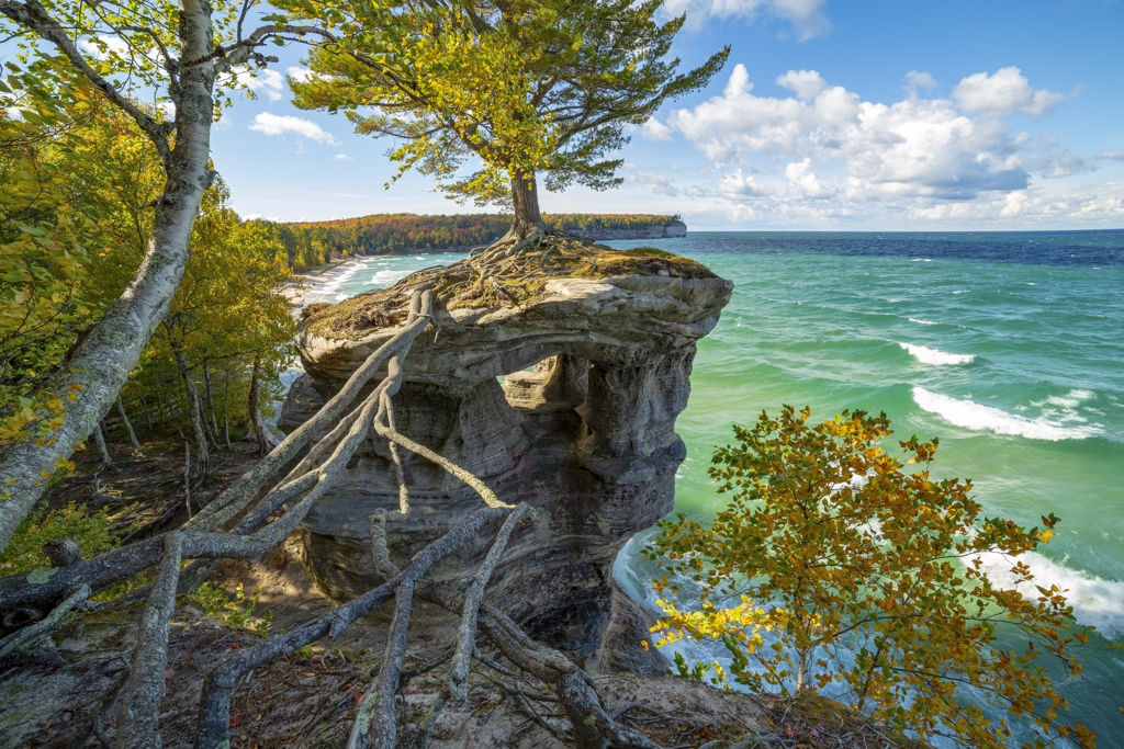
The sandstone formation Chapel Rock, with a lone tree on top, an essential sight when visiting Pictured Rocks.

Chapel Falls is an 80 feet waterfall. Its water comes from Section Creek. It takes approximately an hour to hike to Chapel Falls, which is east of Miner’s Castle Traveling West on H58 from Munising, you will drive approximately 15 miles. About one and a half miles past Melstrand, on the left, you’ll see a sign “Chapel Area.” Remain to the right and follow the signs. You will need to hike about three miles one way from the parking area to the waterfall.

Early European wanderers named this area La Chappelle. Chapel Rock is the remains of Cambrian age sandstone from about 3,800 years ago. Lake Nipissing’s high water carved the sandstone. In the 1940s, the archway that once connected the rock to the mainland collapsed. Today it is connected by only the tree roots.

Spray Falls

Spray Falls plunges into Lake Superior at PIctured Rocks National Shoreline.

Spray Falls is the most remote waterfall and the Lakeshore Trail leads to the top of the falls. It is about a four-mile hike from Chapel Falls. Spray Creek jets about 70 feet over the Pictured Rocks cliffs and then plunges into Lake Superior. About a fourth of a mile east of the falls is a lookout point that affords a safe side view of the falls.  Spray Falls are one of the more popular Pictured Rock attractions, and are included in one of the boat tours. This is a perfect viewing point for the falls.

If You Visit – Other Pictured Rocks Trip Planner Information

A successful trip requires diligent planning and preparation, due to the unpredictable weather patterns of the area. It is wise to check the current conditions on the National Park Service website for instructions needed on any given day.

Here are a few more topics to complete our Pictured Rocks trip planner, to ensure you have all the information you need.

Eating in and Near Pictured Rocks

Plan for a picnic lunch while visiting the Pictured Rocks National Lakeshore. Picnic tables are available; however, there are no restaurants, vending machines, or grocery stores within the boundaries of the lakeshore. You will need to visit one of the surrounding towns to obtain these services.

Muldoon’s

Located in Munising, Muldoon’s pasties were voted number one in Michigan’s Upper Peninsula. Pasties are a typical regional dish. A pasty is a hand-held meat pie, although it is often served on a plate with gravy. Muldoon’s pasties are the Cornish meat pasties made with ground beef, potatoes, onion, carrots, and rutabaga, baked in a piecrust. They also have vegetarian and apple versions available.

Iron Bay Restaurant & Drinkery

Located in downtown Marquette on Iron Bay Harbor, Iron Bay Restaurant & Drinkery is comfort food establishment housed in an historic building that originally housed the Iron Bay Foundry. You’ll find local favorites that include Lake Superior whitefish, including Whitefish chowder, Iron Bay Whitefish tacos and Whitefish tater tots.

Where to Stay in and Near Pictured Rocks National Lakeshore

Camping

If you prefer to stay close to the Pictured Rocks attractions, the National Lakeshore’s backcountry has nearly 100 miles of trails within the park. Running adjacent to Lake Superior, the North Country National Scenic Trail passes through the 42-mile long park. If you choose to camp, drive-in camping fees are $20 per night, and backcountry camping fees are $15 per night.

Hotels

Hampton Inn Marquette Waterfront

The driving distance from Marquette, Michigan to Munising, Michigan, where the Pictured Rocks National Lakeshore is 43 miles away. If you are visiting Pictured Rocks National Lakeshore for a day trip, Marquette is the right spot to overnight. Marquette is the largest city in Michigan’s Upper Peninsula. I stayed at the Hampton Inn Marquette Waterfront. This hotel has a beautiful deck and outdoor space overlooking Lake Superior that makes it a great place to enjoy your morning coffee and watch the sunrise. This hotel is also just a short walk from historic downtown Marquette, where you’ll find several quality restaurants.

Holiday Inn Express Munising – Lakeview

If you prefer to stay in Munising, the Holiday Inn Express Munising – Lakeview has terrific views of Lake Superior. The hotel is near the Lake Superior, the Pictured Rocks National Lakeshore, and Hiawatha National Forest. If you are planning to make your trip last several days and don’t want to camp, this hotel is a good alternative.

What to Pack for Visiting Pictured Rocks

Even in summer, a jacket is necessary. Evenings are cool, and temperatures on Lake Superior may be ten to 15 degrees cooler than on land.

Mosquitoes can be heavy near the wetlands, so personal insect repellent is a must if your visit will include evenings within the parklands.   If you are planning to camp, you may want a broader area insect repellent for your camp area.

Other things you will need will depend on which things to do in Pictured Rocks your plans include.

Are you Ready to Visit Pictured Rocks National Lakeshore?

Pictured Rocks is a perfect getaway place in the Midwest, with an intriguing history, stunning scenery, and plenty of opportunities for outdoor adventure.  If you only have a short time, you can plan an exciting day or weekend trip, and take in a majority of the Pictured Rocks attractions. If you have more time, there are enough things to do in Pictured Rocks to spend a vacation.

We hope our Pictured Rocks Trip Planner has given you all the information that you need to start planning your visit to Pictured Rocks now!

Hey, PIN it so others can plan their trip too!

Looking for other great outdoor places in the United States where you can cool off a bit during a hot summer, or where you can see some brilliant colors in the fall?  You may like:

Acadia National Park

 Rocky Mountain National Park

Niagara Falls

Mammoth Cave National Park

Amy Piper professional shot.

Amy Piper is a freelance travel writer, photographer, and blogger. She is a native of Michigan USA who has traveled to 41 countries and 42 states, most recently adding New Mexico to the list. Her aspiration is to travel to Antarctica and finally visit all seven continents. She travels frequently with her husband, daughter, and granddaughter.  She has been chased by bomb sniffing dogs in the middle of the night in Bogotá (working late), refused boarding for a plane from Buenos Aires to Paraguay (wrong visa), and Federal Marshals once announced her seat number on a plane while looking for a murder suspect. She had traded seats. It is always an adventure!

She is a member of the International Food Wine and Travel Writers Association (IFWTWA), Travel Massive, TravMedia, and the International Travel Writers and Photographers Alliance (ITWPA).  You can find Amy on Twitter @amythe piper, and on Facebook at Follow the Piper.

7 thoughts on “Visiting Pictured Rocks National Lakeshore

  1. ok I have to laugh about the sentence in your bio about the seat change. nice article to read too, I would totally do the excursion where you get dropped off in a kayak. sounds like a real solution for people like me.

  2. This is the first time I have heard about Picture Rocks, so thank you for sharing! For someone that lives out West, what airport would you recommend flying into for the shortest drive to the Lakeshore?

Leave a Reply

Your email address will not be published. Required fields are marked *